By Assefa Mehretu (Ph.D.)
Professor of Geography, Emeritus
Michigan State University
August 18-19, Presented at the 10th International Conference on African Development,
Western Michigan University, Kalamazoo, Michigan 2018
The impetus of this article on issues of boundary delineation in Ethiopia is the existential constitutional crisis created by the ethnic federalism based on tribal enclosures called “killil” in Amharic. In this and other papers that I have published recently (ref. works cited below), I have expressed my opposition to killil. My main reason is that the boundary delineations are gerrymandered; and consequently, they do not meet basic democratic delineation standards of “impartiality, equality, representativeness, non-discrimination and transparency.”
The foregoing principles of delineation are supported by eminent international organizations. The list includes the Organization for Security and Cooperation in Europe, The European Commission for Democracy through Law (the Venice Commission), the Commonwealth Secretariat, and the Electoral Institute of Southern Africa (ref. Lisa Handley cited below).
Political geographers and homeland administrators take the task of boundary delineation for political representation and administration very seriously. Thus, they use a variety of criteria to evaluate the territorial (community of interest) and functional (national integration) qualities of the principal administrative divisions (states or provinces) of the country. They apply objective standards to evaluate the quality of political boundary delineations for the creation of electoral districts, states, or provinces. I have selected seven such tests to evaluate the pre-1974 provincial delineations in Ethiopia and compare their outcomes with the outcomes on the same tests applied to the killil arrangement that replaced them after 1991:
- Are the state or provincial boundaries historic and culturally stable with foundations in natural regions, communities of interest, or cartographic coordinates?
- Are the states or provinces of comparative sizes in surface area with absence of extreme ranges?
- Do the states or provinces reflect a reasonable share of the country’s demographic assets with population thresholds that can support basic cultural, social and development objectives?
- Do the states or provinces reflect a reasonable distribution of the country’s natural resources in a manner that advances their environmental stewardship and sustainability?
- Are the states or provinces accessible to other provinces and metropolitan hubs in the nation to afford dynamic interactive potential for movements of people, ideas, goods and services?
- Do the states or provinces have significant communities of interest and cultural signifiers with hubs that serve as loci of cultural identity, pride, and celebration?
- Do the states or provinces have reasonable “compact” morphology (without extreme deformities) to afford high levels of accessibility by their respective constituencies to the geographic centers of the states or provinces by equitable and effective modes of transportation and communication?
As a brief background, Ethiopia’s pre-1974 provincial delineations were formalized in the Post-WW II years when the central government established the Ethiopian Mapping and Geography Institute. This agency was supported by the United States Mapping Mission, which provided new aerial photographs and remote sensed images of all of Ethiopia. The Mapping and Geography Institute, which later came under the Ministry of Land Reform, had cartographic and cadastral responsibilities for the internal and international boundaries of Ethiopia.Among the outstanding personalities of the time that run the mapping agency and provided the intellectual support on boundary formations were Taye Retta, Mekbib Mamo, and Hailu Wolde Amanuel. These individuals published their works on Ethiopia’s geography in The Ethiopian Geographical Journal.
The Institute also received active support from prominent and accomplished geographers like Professors Mesfin Wolde Mariam and Akalou W. Michael of Haile Selassie I University, Department of Geography (see ref. below).
Thus, the pre-1974 provincial delineations had a considerable intellectual and technical foundation for their formation compared to the 1991 random gerrymanders of the ethnic-based, killil, delineations that lacked serious research, transparency and documentation.
How then would the pre-1974 provinces and the current killils perform given the seven tests listed above? Obviously, it is unrealistic to expect that any boundary delineation, natural or artificial, would fulfill all or any one of the tests listed above completely.
However, the tests against the rubrics offer standards by which we can compare alternative delineations like the pre-1974 provinces and the current killils.
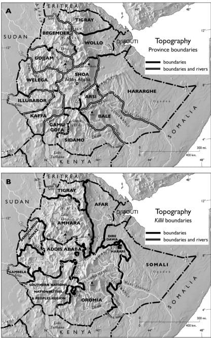
In the following remarks, I will try to show how Ethiopia’s pre-1974 provinces fared against these tests as compared to the respective performance of killils on the same tests using a few comparative maps of provinces and killils (see below):
- Almost all the pre-1974 provinces were historically and culturally stable with boundary delineations that were formed mostly by major river valleys or drainage basins (see map A). There were no known challenges to any of these boundary delineations, with the exception of Arsi which lost its western part to Shoa in the 1950s as the latter, with the locus of political power in Addis Ababa, was designed to afford contiguity with all of Ethiopia’s provinces except Begemder, Tigray and Eritrea.
Killils, on the other hand, claim to have followed ethnic lines of division (communities of interest), a claim which is impossible to achieve at the scale it was done. Even if there were regions of relative linguistic homogeneity (communities of interest) in Ethiopia, there was so much mixing that has been going on for centuries that a tribal delineation on the ground at a scale it was done had to be an exercise in random gerrymandering with no natural or historical underpinning (compare maps A and B).
- Almost all of the pre-1974 provinces were viable large areas whose boundaries remained relatively stable throughout the 1950s, 60s and 70s. There were fourteen provinces of which only one, Arsi, which lost territory to Shoa, could be considered relatively small. Hararghe was the largest province in area but it did not have the comparative demographic power as the other provinces. The other twelve provinces (excluding Eritrea) were generally large without excessive variability in territorial size between them.
The killil arrangement, on the other hand, allocated the bulk of Ethiopia’s landmass (minus Eritrea) to three killils, Oromo, Amhara and Southern Nations. It also created some relatively small killils like Gambella and Benishangul and tucked them away into isolation on the Sudan border.
It also created the Afar and Somali killils in the most arid and drought-prone margins of Ethiopia (compare maps A and B; and C and D).
- The pre-1974 provinces of Ethiopia enjoyed an equitable share of the country’s most populated plateau regions of the central highlands (see map A). This served to guarantee each province to afford population thresholds for basic government services like schools, hospitals, banks, etc. as well as commercial enterprises (industries, banks, etc.)
Almost all of the pre-1974 provinces (with the exception of Shoa and Arsi) were designed to integrate low-population-density regions at the border with Sudan, Kenya and Somalia with higher-population-density plateaus in the middle of the country (see map A). On the contrary, killils allocated most of the population of the country to Oromo, Amhara and Southern Nations leaving killils like Gambella, Benishangul, Somali and Afar isolated in underpopulated and underserved margins of the country lacking viability and regional complementarity with the rest of the country (see map B).
- All of the pre-1974 provinces provided an equitable share of Ethiopia’s natural resources including hydrographic, climatic and topographic assets in which all except Shoa and Arsi extended from the international boundaries with Sudan, Kenya and Somalia (low-lying, hot and arid regions), to the Central Ethiopian Plateaus (temperate and more moist regions). Shoa and Arsi also enjoyed these varied agro-climatic regions because of the Rift Valley and its escarpments. As most provinces were within integrated watersheds, they were also suitable to allocate uniform responsibility for stewardship of land resources and environmental safeguards (see map A).
Killils, on the other hand, cut off Benishangul, Gambela, Afar and Somali from having access to highland hinterlands for cultural, agricultural and commercial complementarity, restricting them to mostly arid areas while allocating most of the central highlands and associated lowlands and their rich natural resources to three of the nine regions of Oromia, Amhara and Southern Nations (compare maps A and B; and C and D). Furthermore, with killil boundaries claiming to follow tribal lines of division, they made massive truncations of the principal watersheds of Ethiopia putting their stewardship and environmental protections into multiple and diffuse killil administrations (see Map B).
- The pre-1974 provinces were associated with high levels of contiguity and accessibility to each other; the central hubs within Shoa, major transport arteries that radiated from Addis Ababa, and the principal urban centers of the country. They also enjoyed access to the principal public and private urban functions like bank branches (see maps E and F) anchored in large towns like Nekemte, Debre Markos, Gondar, Mekele, Dessie, Arsi, Harar, Jimma, Yirgalem, Gore, etc., most of which enjoyed direct air and land transport access to the primate city of Addis Ababa.
Here again, the killil arrangement ruined the highly articulated system of spatial integration prior to 1974 with the creation of unwieldy disarticulated killils like Oromia, Amhara, Southern Nations, etc. with laws that negated Ethiopia’s time honored regional complementarities, and instead supported exclusionary, jingoistic and dangerous covenants of segregation that intimated (and in a few cases resulted in) ethnic cleansings.At the same time, the killil provision denied access and complementarity to Benishangul, Gambela, Afar and Somali with known metropolitan markets and functions that they had depended on for hundreds of years (see maps E and F).
- On cultural identity and communities of interest, while manifesting a healthy diversity of all of Ethiopia’s ethnic groups, the pre-1974 provinces were at the same time dominated by one of Ethiopia’s major linguistic groups (Amharas in Gojjam, Oromos in Wellega, Tigre’s in Tigray, Somalis in Harerghe, etc.).
As their boundaries were mostly delineated by major rivers, they were not designed to dilute or weaken any of Ethiopia’s major linguistic groups and their communities of interest. For instance, prior to 1974, Ethiopians proudly identified with the provinces from which they came. They called themselves the sons/daughters of Harar, Shoa, Sidamo or Wellega, etc. Yet, their loyalty was always with Ethiopia, their country.
The pre-1974 provinces also manifested cultural hubs like Nekemte, Debre Markos, Gonder, Makele, Adwa, Asela, Adama, Harar, Dire Dawa, Yirgalem, Desse, Jimma, Gore, etc. These attractive and seductive hubs and others like them had made Ethiopians from any of the provinces feel at home and they had visited them freely for business, education, and pleasure. In the pre-1974 provincial administrative order, people not only enjoyed the pride of spatial identity (community of interest – sons/daughters from my land; my river) but also the advantage of mobility (for national integration). Political geography teaches that both territoriality (communities of interest) and functionality (national integration) are important virtues of administrative regions of any country that seeks to advance peace and progress for its people (for details on these concepts, ref. John Friedmann cited below). The pre-1974 provinces did meet that test.The killil system, on the other hand, by forcibly implementing region-based ethnic covenants, enabled ethno-nationalists to rationalize cases of violent ethnic cleansings. Consequently, the killil system ruined the “unity in diversity” ethos, the hallmark of Ethiopia’s exceptionality in Africa as a multicultural polity that has prevailed for centuries (ref. Clapham cited below).
- Finally, on the criterion of territorial morphology, geographers classify territorial shapes of states or provinces into five categories: compact, fragmented, elongated, perforated, and protruded.Compact morphology is considered the best of all types because territorial compactness is advantageous for both communal (local) as well as functional (national) objectives. All the other morphological types are not ideal and pose difficulty for the administration of public as well private services.
A study of the pre-1974 Ethiopian provinces along this line shows a high degree of compactness (see map A) for almost all provinces with the exception of Hararghe. With their relative compactness, the pre-1974 provinces offered their respective constituencies a high degree of integration and interaction with the geographic centers of their respective provincial hubs of government as well as commercial and social functions.This quality of morphological compactness of the pre-1974 provinces is totally absent in the artificially gerrymandered morphology of killils. For instance, Oromia has a classic case of a protruded, panhandled and boomerang morphology and an administrate region whose shape is without precedence. Afar, Tigray and Somali killils can be characterized as being elongated. The Southern Nations killil is characterized by a degree of deformity that it approaches the typology of perforation (compare maps A and B).Based on the foregoing analyses, therefore, the pre-1974 provincial boundaries, unlike killils, fare well against the seven principles of delineation.
In other words, there is a geographic rationale for restoring the pre-1974 provincial boundaries with reasonable modifications thereof, if necessary.
Furthermore, a provincial federation system is much preferred to ethnic federalism for peace and development by many scholars in the field.
Geographers have dealt with the issue of delineation for a long time and they have indicated that delineation of tribal territories for political governance is a dangerous proposition. I would like to quote Nuala C. Johnson (cited below), for her profound warning on this matter (the italics are mine): “Confirming the link between specific people (e.g. Oromo or Amhara) and a place has been hotly disputed…as the cultural geography of places rarely represents an ethnically homogenous piece of land (e.g. Oromia or Amhara killils). Consequently, the demarcation of national (tribal) territory has been fraught with difficulties which at times have resulted in the most violent territorial disputes.”
For further readings refer to:
- Clapham, C. 1988. Transformation and Continuity in Revolutionary Ethiopia. Cambridge University Press, p. 195.
- Friedmann, J. 1988: Life space and economic space: Essays in Third World planning. Transaction Books.
- Friedmann, J. and Weaver, C.C. 1979: Territory and Function: The Evolution of Regional Planning. The University of California Press.
- Handley, Lisa. 2007. “Challenging the Norms of and Standards of Election Administration: Boundary Delimitation.” In Challenging the Norms and Standards of Election Administration. IFES and USAID, pp. 59-74.
- Johnson, N.C. 2002. “The Renaissance of Nationalism.” In Johnston, R.J., Taylor, P.J. and Watts, M., editors, Geographies of Global Change: Remapping the World. Blackwell Publishing, pp. 130–42.
- Mehretu, Assefa. 2011. “Delegitimizing Multicultural Collective Identity in Ethiopia: A Critical Reflection on Ethnic Federalism.” Horn of Africa, Volume XXIX, pp. 64-82.
- Mehretu, Assefa. 2012. “Ethnic Federalism and its Potential to Dismember the Ethiopian State.” Progress in Development Studies, Volume 12, Nos. 2&3, pp. 113-133.
- Mehretu, Assefa. 2017. “Delegitimization of the Collective Identity of Ethiopianism” International Journal of Ethiopian Studies,Volume XI, No. 1, pp. 45-70.
- Wolde-Mariam, Mesfin. 1970. An Atlas of Ethiopia.Addis Ababa: Haile Selassie I University.
- Wolde-Mariam, Mesfin. 1972. An Introductory Geography of Ethiopia.Addis Ababa: Haile Selassie I University.
የኢትዮጵያ የተፈጥሮ መልክአ–ምድርን ጠባይ ያዘሉ ዋና የአስተዳደር ክፍፍል ካርታዎች።
- ከ 1974 በፊት የነበሩት አብዛኛውን በመልክአ-ምድራዊ መሰረት የተዋቀሩ ክፍለ ሃገራት።
- ከ 1991 በኋላ ለጎሳ ስብስብ መለያያ የተዋቀሩ ሰው-ፈጠር ክልሎች።